Cycling village
- gailgriggs
- Sep 1, 2019
- 2 min read
Updated: Mar 27
As part of its commitment to the Health & Wellbeing initiative, Holmes Chapel Partnership has tried to promote cycling and walking as alternatives to car travel.
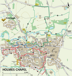
In 2012 we produced our first cycling map, showing suggested routes within the village avoiding the main roads (as far as possible). This was followed up in 2013 by a second map “Cycle Rides around Holmes Chapel” showing circular routes of various lengths outside the village, to encourage individuals and families to venture out into the countryside, again, as far as possible, avoiding main roads.
We were proud to be a founder member of SECCAG (the South East Cheshire Cycling Action Group) who were involved in developing the Cheshire East Cycling Strategy. This group pressures Cheshire East to try and make sure that this strategy is a reality rather than an aspiration. In 2013 SECCAG published a map, “Let’s Go Cycling in SE Cheshire”, showing cycling routes within and between the 5 local Partnership towns - Alsager, Congleton, Middlewich, Sandbach and Holmes Chapel. This map was updated in 2017 and 2022.
2017 also saw the production of a walking map “Walks around Holmes Chapel”. This map was originally designed to suggest a few, pleasant, mostly traffic-free, walks to new residents of our village but can still prompt longer term residents to a car-free bit of exercise and fresh air.
2019 saw the publication of a new walking map – the “South Cheshire 5 Towns Trail” – on which the Partnerships from the five towns that used to form Congleton Borough have collaborated. It describes routes using Public Footpaths to get from one town to another and, for the ambitious, a 43 mile round route!
Download the maps here:
#southeastcheshirecyclingactiongroup #holmeschapel #southcheshiremarkettownstrail #walkingmaps #cyclingmaps


Comentarios